Mastering Overpass QL: A Hands-On Guide to Extracting Custom OSM Data with Precision and Ease
The Overpass API is a powerful and efficient way to extract targeted geographic data from OpenStreetMap (OSM). Instead of downloading large and complex OSM datasets, the Overpass API lets you query and retrieve only the specific data they need, such as buildings, roads, or amenities, based on location or tags.
At its core is the Overpass Query Language (Overpass QL) — a flexible scripting language that makes it easy to filter, search, and process OSM data. Whether you’re looking for bus stops in London, rivers in Germany, or cycling infrastructure in Amsterdam, Overpass QL helps you access precise OSM data for your project.
Understanding Overpass Query Language (Overpass QL)
Overpass QL is a declarative language that describes what data to retrieve rather than how to retrieve it. It is structured around:
- Data Types: Nodes (points), Ways (lines/polygons), and Relations (grouped elements).
- Filters: Selecting elements based on location, tags, and attributes.
- Output Options: Controlling what data is returned and in what format.
Basic Structure of an Overpass Query
A typical Overpass QL query consists of:
- A bounding box or area filter (optional but recommended for efficiency).
- A query to select elements (nodes, ways, or relations).
- Filters to refine results based on tags or properties.
- An output statement to format the results.
Basic Overpass QL Queries
1. Find All Cafés in Paris
This query retrieves all cafés (amenity=cafe) within the city of Paris:
[out:json];
area[name="Paris"]->.searchArea;
node["amenity"="cafe"](area.searchArea);
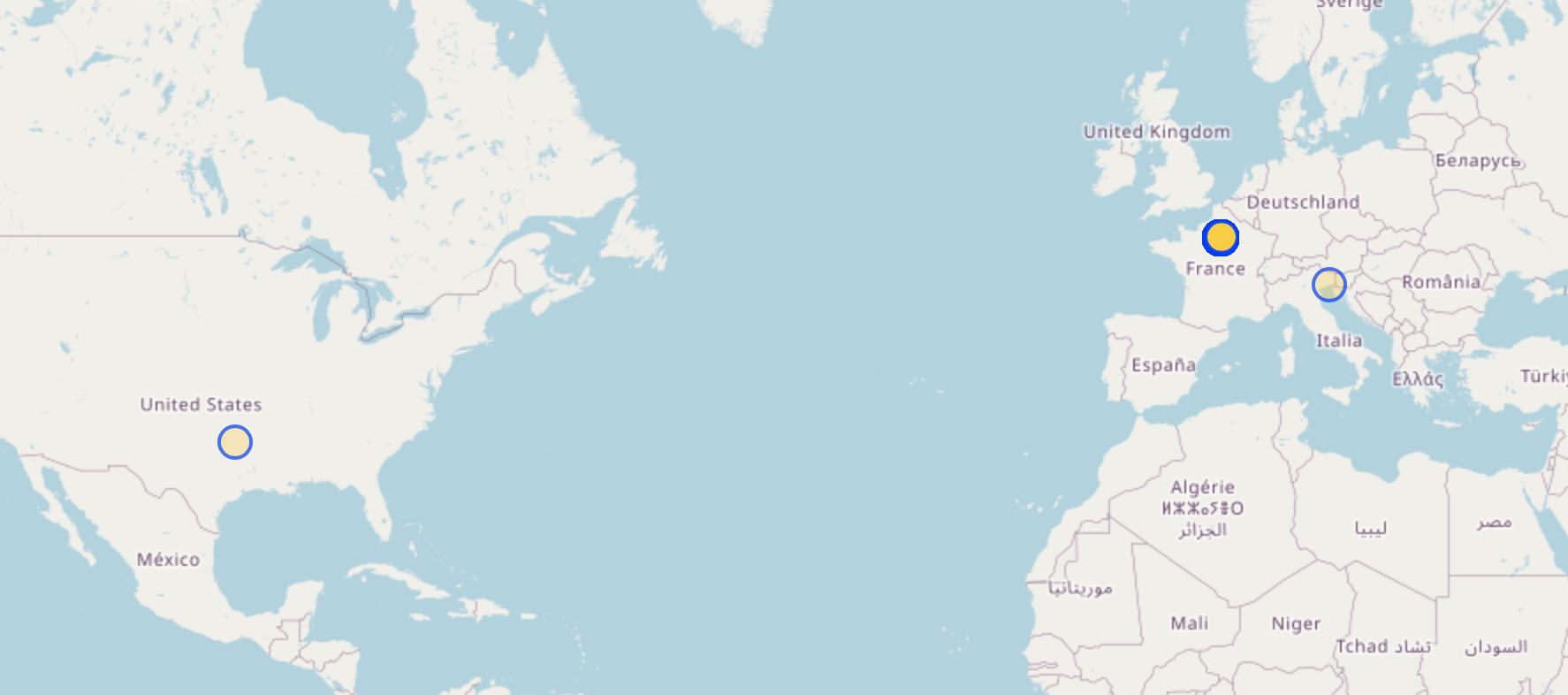
out body;Paste the query here and you’ll see there is a city called Paris in the US and a cafe in Lignano, Italy in a hotel with the tag name=Paris.
If you want to focus on only Paris, France, use the bounding box. To get the bounding box coordinates:
- zoom the map around Paris
- run:
relation({{bbox}});
out count({{bbox}}); /* only return counts to keep the query light */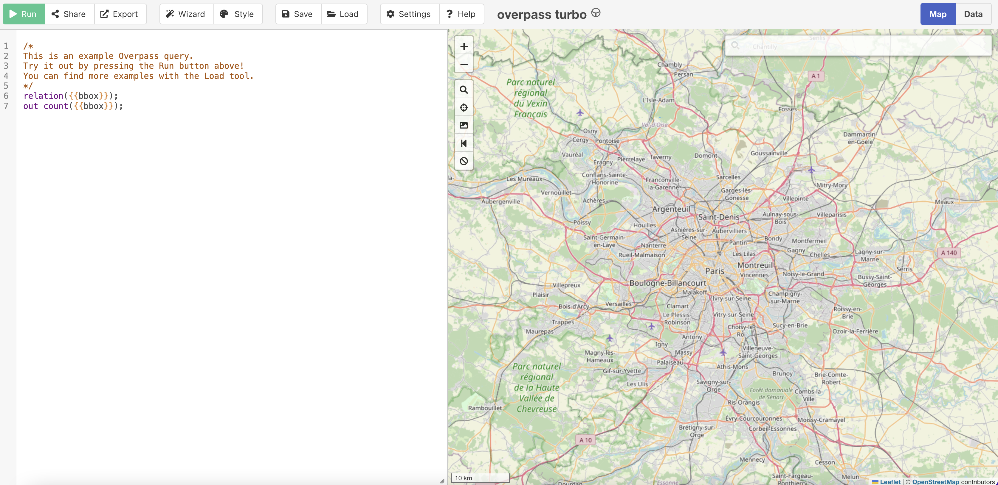
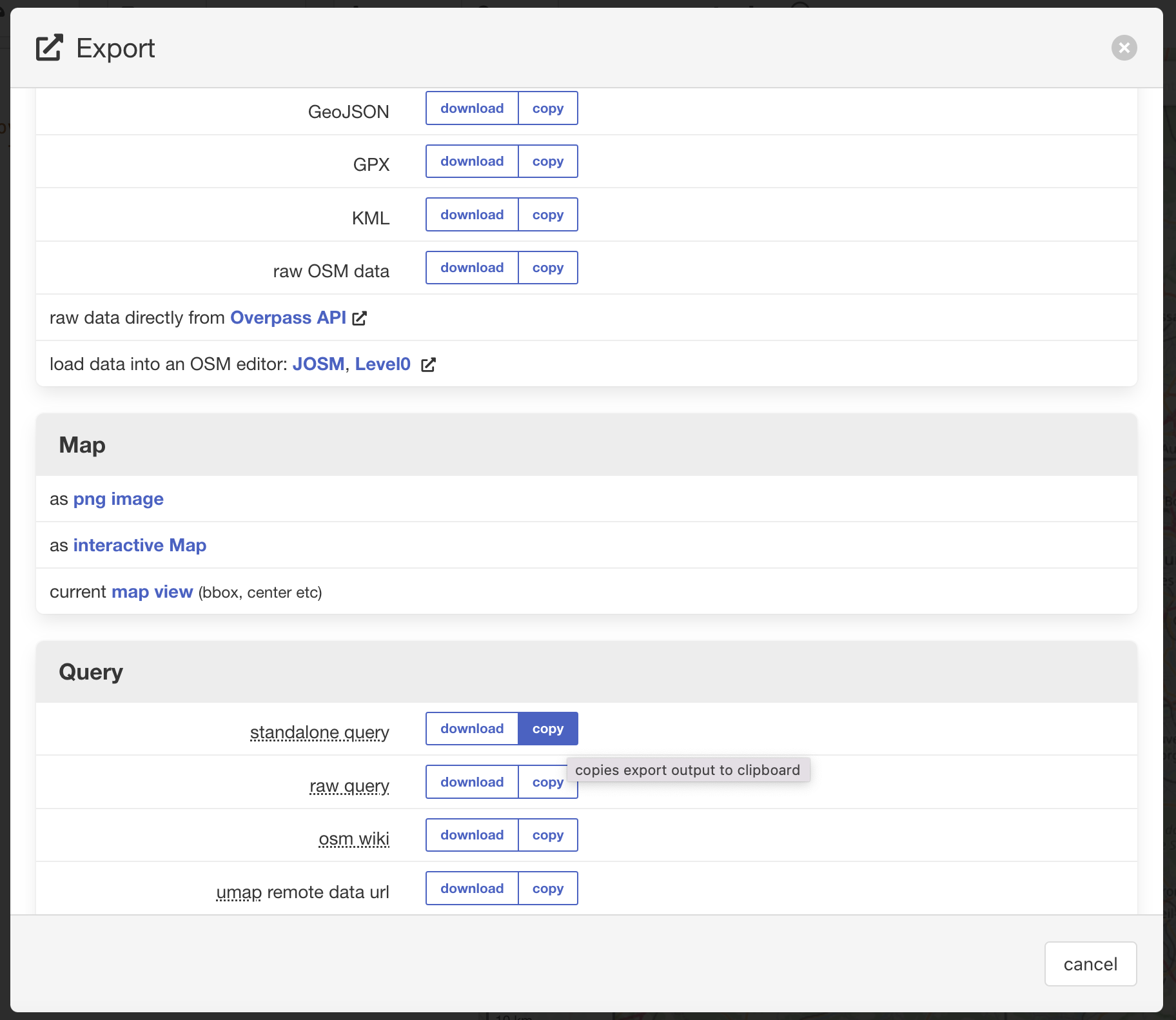
- click export
- copy standalone query
you get the query above with the actual bounding box coordinates, that you can use in other queries or API calls:
relation(48.525700252688765,1.7330932617187502,49.21939110725795,3.0006408691406254);
out count(48.525700252688765,1.7330932617187502,49.21939110725795,3.0006408691406254);
The bounding box (48.52,1.73,49.22,3.00) represents (South Latitude, West Longitude, North Latitude, East Longitude), in other words: bottom-left top-right coordinates.
Now you can filter on the boundary coordinates of Paris, France as well as on the area name.
[out:json];
area[name="Paris"]->.searchArea;
node["amenity"="cafe"](area.searchArea)(48.52,1.73,49.22,3.00);
out body;
This query only returns results in Paris, France:
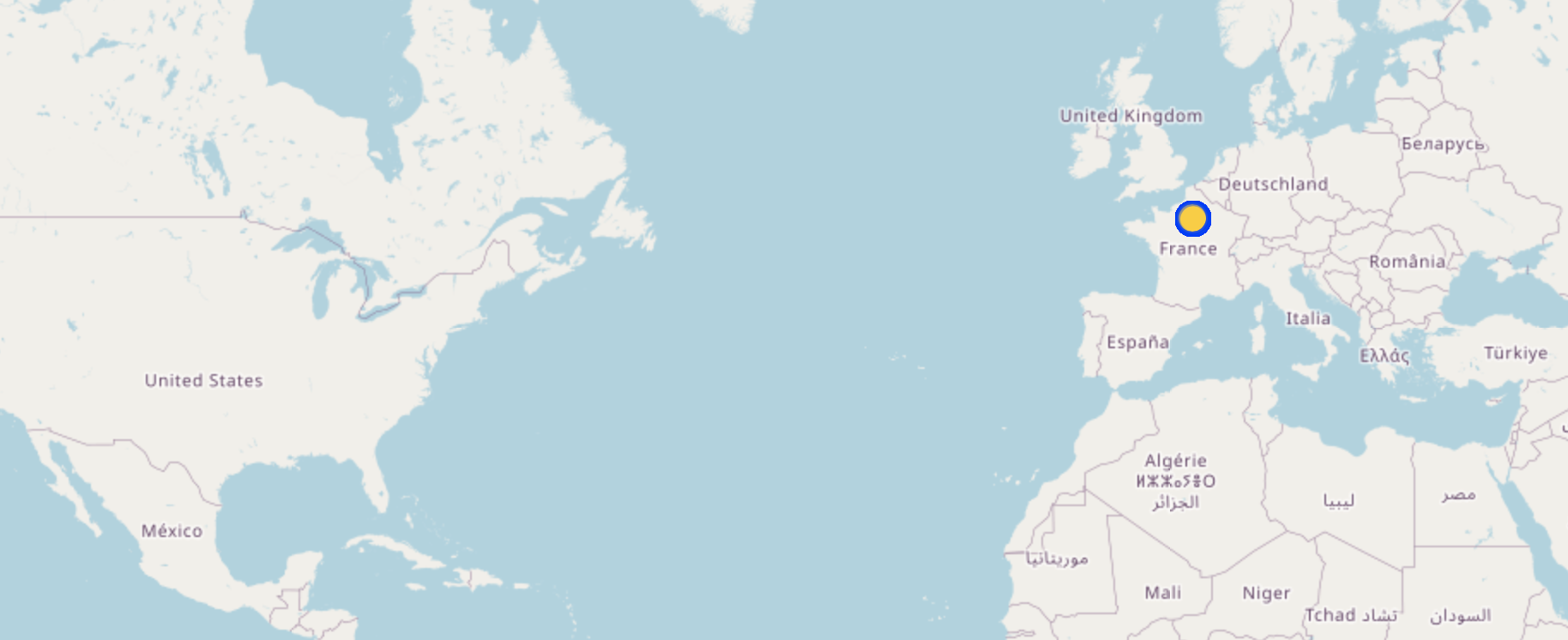
The query above combines both area filters and bounding boxes, but it’s important to know how they differ. area[name="Paris"] uses OSM’s administrative boundaries (like city limits), but as we saw it’s prone to data entry errors. (48.52,1.73,49.22,3.00) is a coordinate-based bounding box. Overpass will return results that match both conditions — i.e., cafés within the named Paris area and within the bounding box.
2. Get All Highways in a Specific Bounding Box
This query finds all highways (roads, paths, etc.) within a specific latitude/longitude bounding box:
[out:json];
way["highway"](48.52,1.73,49.22,3.00);
out geom;- The
["highway"]filter selects all road-related features. - The
out geom;statement returns full geometries (lat/lon coordinates).
3. Find Bus Stops Near Berlin and Export as .csv
To find public transport bus stops around Berlin and output the Overpass QL query as a CSV, use the out:csv statement and specify the fields you want in the output.
The following query:
[out:csv(::id, name, ::lat, ::lon)];
area["name"="Berlin"]->.searchArea;
node["highway"="bus_stop"](area.searchArea);
out;- Searches for all nodes tagged with
"highway"="bus_stop"within that area. - Defines the Berlin area using its name.
- Outputs the data in CSV format:
out:csv(::id, name, ::lat, ::lon);**::id→ OSM node ID (unique identifier).name→ The name of the bus stop (if available).::lat, ::lon→ Latitude and longitude coordinates.
The Output for CSV Data
@id,name,@lat,@lon
27239370,Hahneberg,52.5238455,13.1449355
27587012,U Olympia-Stadion,52.5165172,13.2491345
27586412,Güterbahnhof Ruhleben,52.5283572,13.2203842
Advanced Overpass QL Features
4. Fetching Only Recent Changes (Changed in the Last 7 Days)
If you need to monitor recent changes, Overpass can fetch only the data modified within the last week:
[out:json];
way["highway"](newer:"2024-03-25T00:00:00Z");
out geom;
This retrieves all roads that have been edited since March 25, 2024.
5. Finding Buildings with Missing Addresses
To identify buildings without an address tag in New York:
[out:json];
area[name="New York"]->.searchArea;
way["building"](area.searchArea);
(._; - way["addr:housenumber"](area.searchArea););
out geom;
This Overpass QL query is designed to find buildings in New York that are missing an address (addr:housenumber). Let’s break it down line by line:
-
[out:json];Sets the output format to JSON. (Overpass API supports different output formats, e.g., XML, CSV, JSON). -
area[name="New York"]->.searchArea;:- finds the administrative boundary of New York,
->.searchArea;stores the result in a variable called.searchAreafor later use. - Why use
area? OpenStreetMap stores large administrative boundaries as relations instead of nodes or ways. Directly searching within a bounding box can be inefficient, so using an area filter is often better.
- finds the administrative boundary of New York,
-
**
way["building"](area.searchArea);Finds all ways (polygons) tagged as “building” inside the New York area. A way is a collection of nodes that form a line or polygon. Buildings are usually represented as closed ways (polygons). -
**
(._; - way["addr:housenumber"](area.searchArea););**Filters out buildings that already have an address (addr:housenumber). Breaking it down:._;→ Refers to the previous selection (all buildings in New York).way["addr:housenumber"](area.searchArea);→ Finds buildings that have an address (addr:housenumber).-(minus operator) → Removes buildings that already have an address from the previous selection.
As end result the query keeps only buildings that are missing an address.
-
out geom;: Outputs the final result, including geometries (latitude/longitude coordinates).out geom;→ Returns metadata with geometry data (coordinates of buildings).out body;→ Returns only metadata without geometry.
Output Formats
Overpass API supports different output formats depending on your needs:
- JSON (
out:json;) – Easy to parse and use in web applications. - XML (
out:xml;) – Useful for structured data processing. - CSV (
out:csv(name,lat,lon);) – Ideal for spreadsheets. - Map Display (
out meta;) – Can be visualised directly in Overpass Turbo.
For example, to output only node IDs and coordinates in CSV format:
[out:csv(::id, ::lat, ::lon)];
area[name="London"]->.searchArea;
node["amenity"="restaurant"](area.searchArea);
out;
Running Overpass Queries
1. Using Overpass Turbo (Web Interface)
The easiest way to test Overpass QL queries is via Overpass Turbo. It provides:
- A map-based interface to run and visualize queries.
- Auto-formatting for Overpass QL.
- Export options (GeoJSON, KML, GPX).
2. Using Overpass API Directly (Command Line or Scripts)
For programmatic access, use the Overpass API endpoint:
curl -X GET "https://overpass-api.de/api/interpreter" --data-urlencode 'data=[out:json];area[name="Paris"]->.searchArea;node["amenity"="cafe"](area.searchArea);out body;'Or in Python using requests:
import requests

query = """
[out:json];
area[name="Berlin"]->.searchArea;
node["amenity"="bicycle_rental"](area.searchArea);
out body;
"""
url = "https://overpass-api.de/api/interpreter"
response = requests.get(url, params={'data': query})
data = response.json()
Conclusion
The Overpass API Query Language is a versatile and efficient tool for extracting custom OSM data. Whether you’re looking for specific amenities, analysing transportation networks, or tracking changes in geographic data, Overpass QL provides a powerful way to interact with OpenStreetMap.
If you’re new to Overpass QL, start with simple queries in Overpass Turbo, then explore more advanced filtering techniques as you get comfortable.
Try running queries on Overpass Turbo and experiment with real-world data!